 Checklists
 Personal Shopping
 Boot Fitting


Trails Illustrated Nat Geo
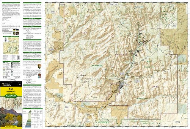
Zion Map
item # 214
$14.95
- Covering all of Zion National Park, our Trails Illustrated map contains detailed topography with shaded relief, up-to-date trails, roads, and points of interest, plus trail summaries and useful information to get the most from your visit
- The North side of the map covers the popular Zion Narrows with a companion hiking timetable, plus Kolob Canyons, La Verkin Creek Trail, Hop Valley Trail, Wildcat Canyon, the West Rim Trail, and more
- The South side of the map details the park headquarters, Floor of the Valley Road, East Rim Trail, Telephone Canyon Trail, and the Virgin River
- Both sides feature a UTM and Latitude/Longitude grid for use with a GPS, plus compass rose, scale bar and legend for easy interpretation
- Dimensions:Approximately 4 1/4inches x 9 1/4inches folded; 26inches x 38inches fully opened
- Scale: 1:37, 700
- Revision Date: 2012
- Construction:
- More than just a map, National Geographic Trails Illustrated topographic maps are designed to take you into the wilderness and back. Printed on tear-resistant, waterproof material, this map can go anywhere you do. Each map is based on exact reproductions of USGS topographic map information, updated, customized, and enhanced to meet the unique features of each area. The maps include valuable wilderness tips and Leave No Trace guidelines, along with updated trails, trailheads, points of interest, campgrounds, and much more. With a new color palette and stunning shaded relief, backcountry navigation has never been easier.