 Checklists
 Personal Shopping
 Boot Fitting

Ozark Trail Assoc
Invalid Product
Ozark Trail North Fork Section
item # NORTHFORK
$12.95
| struct | |||||||||||||||||||||||||||||||||||||||||||||||||||||||||||||||||||||||||||||||||||||||||||||||||||
|---|---|---|---|---|---|---|---|---|---|---|---|---|---|---|---|---|---|---|---|---|---|---|---|---|---|---|---|---|---|---|---|---|---|---|---|---|---|---|---|---|---|---|---|---|---|---|---|---|---|---|---|---|---|---|---|---|---|---|---|---|---|---|---|---|---|---|---|---|---|---|---|---|---|---|---|---|---|---|---|---|---|---|---|---|---|---|---|---|---|---|---|---|---|---|---|---|---|---|---|
| Detail | [empty string] | ||||||||||||||||||||||||||||||||||||||||||||||||||||||||||||||||||||||||||||||||||||||||||||||||||
| ErrorCode | [empty string] | ||||||||||||||||||||||||||||||||||||||||||||||||||||||||||||||||||||||||||||||||||||||||||||||||||
| ExtendedInfo | [empty string] | ||||||||||||||||||||||||||||||||||||||||||||||||||||||||||||||||||||||||||||||||||||||||||||||||||
| Message | Invalid Product | ||||||||||||||||||||||||||||||||||||||||||||||||||||||||||||||||||||||||||||||||||||||||||||||||||
| StackTrace | coldfusion.runtime.CustomException: Invalid Product at coldfusion.tagext.lang.ThrowTag.doStartTag(ThrowTag.java:87) at coldfusion.runtime.CfJspPage._emptyTag(CfJspPage.java:5264) at cfpurchasing2ecfc2030940348$funcINIT.runFunction(E:\websites\stratusecommerce\functions\purchasing.cfc:23) at coldfusion.runtime.UDFMethod.invoke(UDFMethod.java:662) at coldfusion.runtime.UDFMethod$ReturnTypeFilter.invoke(UDFMethod.java:592) at coldfusion.runtime.UDFMethod$ArgumentCollectionFilter.invoke(UDFMethod.java:555) at coldfusion.filter.FunctionAccessFilter.invoke(FunctionAccessFilter.java:95) at coldfusion.runtime.UDFMethod.runFilterChain(UDFMethod.java:471) at coldfusion.runtime.UDFMethod.runFilterChain(UDFMethod.java:445) at coldfusion.runtime.UDFMethod.invoke(UDFMethod.java:720) at coldfusion.runtime.TemplateProxy.invoke(TemplateProxy.java:980) at coldfusion.runtime.TemplateProxy.invoke(TemplateProxy.java:762) at coldfusion.runtime.CfJspPage._invoke(CfJspPage.java:4238) at coldfusion.runtime.CfJspPage._invoke(CfJspPage.java:4202) at cfproducts2ecfm1519473807._factor15(E:\websites\stratusecommerce\products.cfm:423) at cfproducts2ecfm1519473807._factor16(E:\websites\stratusecommerce\products.cfm:233) at cfproducts2ecfm1519473807._factor17(E:\websites\stratusecommerce\products.cfm:1) at cfproducts2ecfm1519473807.runPage(E:\websites\stratusecommerce\products.cfm:1) at coldfusion.runtime.CfJspPage.invoke(CfJspPage.java:257) at coldfusion.tagext.lang.IncludeTag.handlePageInvoke(IncludeTag.java:749) at coldfusion.tagext.lang.IncludeTag.doStartTag(IncludeTag.java:578) at coldfusion.runtime.CfJspPage._emptyTcfTag(CfJspPage.java:5274) at cfapplication2ecfc1458786127$funcONREQUEST.runFunction(E:\websites\stratusecommerce\application.cfc:295) at coldfusion.runtime.UDFMethod.invoke(UDFMethod.java:662) at coldfusion.runtime.UDFMethod$ReturnTypeFilter.invoke(UDFMethod.java:592) at coldfusion.runtime.UDFMethod$ArgumentCollectionFilter.invoke(UDFMethod.java:555) at coldfusion.filter.FunctionAccessFilter.invoke(FunctionAccessFilter.java:95) at coldfusion.runtime.UDFMethod.runFilterChain(UDFMethod.java:471) at coldfusion.runtime.UDFMethod.runFilterChain(UDFMethod.java:445) at coldfusion.runtime.UDFMethod.invoke(UDFMethod.java:317) at coldfusion.runtime.TemplateProxy.invoke(TemplateProxy.java:975) at coldfusion.runtime.TemplateProxy.invoke(TemplateProxy.java:696) at coldfusion.runtime.TemplateProxy.invoke(TemplateProxy.java:503) at coldfusion.runtime.AppEventInvoker.invoke(AppEventInvoker.java:115) at coldfusion.runtime.AppEventInvoker.onRequest(AppEventInvoker.java:308) at coldfusion.filter.ApplicationFilter.invoke(ApplicationFilter.java:569) at coldfusion.filter.RequestMonitorFilter.invoke(RequestMonitorFilter.java:43) at coldfusion.filter.MonitoringFilter.invoke(MonitoringFilter.java:40) at coldfusion.filter.PathFilter.invoke(PathFilter.java:162) at coldfusion.filter.IpFilter.invoke(IpFilter.java:45) at coldfusion.filter.ExceptionFilter.invoke(ExceptionFilter.java:97) at coldfusion.filter.BrowserDebugFilter.invoke(BrowserDebugFilter.java:81) at coldfusion.filter.ClientScopePersistenceFilter.invoke(ClientScopePersistenceFilter.java:28) at coldfusion.filter.BrowserFilter.invoke(BrowserFilter.java:38) at coldfusion.filter.NoCacheFilter.invoke(NoCacheFilter.java:60) at coldfusion.filter.GlobalsFilter.invoke(GlobalsFilter.java:38) at coldfusion.filter.DatasourceFilter.invoke(DatasourceFilter.java:22) at coldfusion.filter.CachingFilter.invoke(CachingFilter.java:62) at coldfusion.CfmServlet.service(CfmServlet.java:231) at coldfusion.bootstrap.BootstrapServlet.service(BootstrapServlet.java:311) at org.apache.catalina.core.ApplicationFilterChain.internalDoFilter(ApplicationFilterChain.java:199) at org.apache.catalina.core.ApplicationFilterChain.doFilter(ApplicationFilterChain.java:144) at coldfusion.monitor.event.MonitoringServletFilter.doFilter(MonitoringServletFilter.java:46) at coldfusion.bootstrap.BootstrapFilter.doFilter(BootstrapFilter.java:47) at org.apache.catalina.core.ApplicationFilterChain.internalDoFilter(ApplicationFilterChain.java:168) at org.apache.catalina.core.ApplicationFilterChain.doFilter(ApplicationFilterChain.java:144) at org.apache.catalina.core.StandardWrapperValve.invoke(StandardWrapperValve.java:168) at org.apache.catalina.core.StandardContextValve.invoke(StandardContextValve.java:90) at org.apache.catalina.authenticator.AuthenticatorBase.invoke(AuthenticatorBase.java:482) at org.apache.catalina.core.StandardHostValve.invoke(StandardHostValve.java:130) at org.apache.catalina.valves.ErrorReportValve.invoke(ErrorReportValve.java:93) at org.apache.catalina.core.StandardEngineValve.invoke(StandardEngineValve.java:74) at org.apache.catalina.connector.CoyoteAdapter.service(CoyoteAdapter.java:357) at org.apache.coyote.ajp.AjpProcessor.service(AjpProcessor.java:448) at org.apache.coyote.AbstractProcessorLight.process(AbstractProcessorLight.java:63) at org.apache.coyote.AbstractProtocol$ConnectionHandler.process(AbstractProtocol.java:936) at org.apache.tomcat.util.net.NioEndpoint$SocketProcessor.doRun(NioEndpoint.java:1791) at org.apache.tomcat.util.net.SocketProcessorBase.run(SocketProcessorBase.java:52) at org.apache.tomcat.util.threads.ThreadPoolExecutor.runWorker(ThreadPoolExecutor.java:1190) at org.apache.tomcat.util.threads.ThreadPoolExecutor$Worker.run(ThreadPoolExecutor.java:659) at org.apache.tomcat.util.threads.TaskThread$WrappingRunnable.run(TaskThread.java:63) at java.base/java.lang.Thread.run(Thread.java:834) | ||||||||||||||||||||||||||||||||||||||||||||||||||||||||||||||||||||||||||||||||||||||||||||||||||
| Suppressed |
|
||||||||||||||||||||||||||||||||||||||||||||||||||||||||||||||||||||||||||||||||||||||||||||||||||
| TagContext |
|
||||||||||||||||||||||||||||||||||||||||||||||||||||||||||||||||||||||||||||||||||||||||||||||||||
| Type | Application | ||||||||||||||||||||||||||||||||||||||||||||||||||||||||||||||||||||||||||||||||||||||||||||||||||
| code | [empty string] | ||||||||||||||||||||||||||||||||||||||||||||||||||||||||||||||||||||||||||||||||||||||||||||||||||
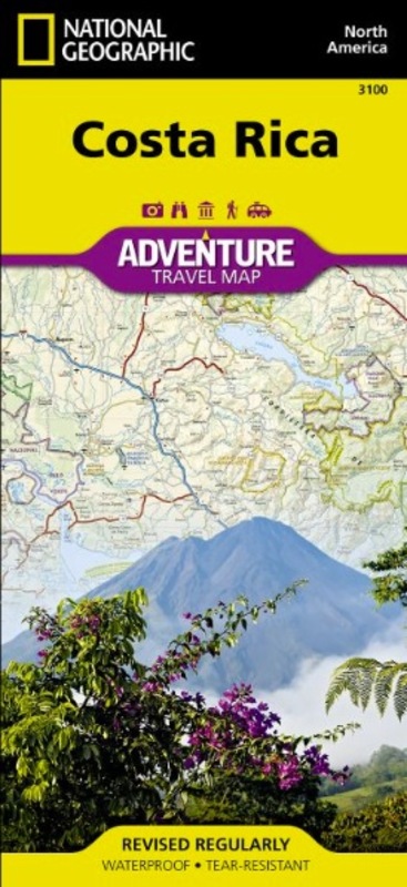
- The Ozark Trail Association is now offering high-quality printed Ozark Trail section maps for purchase. Each map is printed on water and tear resistant paper and folds to 7.5 x 3.5 inches to easily fit in your pocket or pack. Features:
- Included on each map is complete topography, elevation profile, trailheads and directions, water sources, safety information and emergency contacts, weather tips and more. The maps also feature photos and information about historical and natural points of interest.
- Pomona Trailhead to Collins Ridge, highlighting Lover's Leap, Noblett Lake Recreation area and access to Ridge Runner Trail, Blue Spring and Devil's Backbone.
- Fabric: Water and tear resistant paper
- Size: 7.5 x 3.5 inches