 Checklists
 Personal Shopping
 Boot Fitting

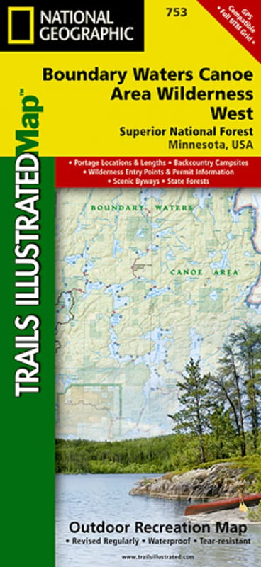
Trails Illustrated Nat Geo
Invalid Product
Big Bend Map
item # 225
$14.95
| struct | |||||||||||||||||||||||||||||||||||||||||||||||||||||||||||||||||||||||||||||||||||||||||||||||||||
|---|---|---|---|---|---|---|---|---|---|---|---|---|---|---|---|---|---|---|---|---|---|---|---|---|---|---|---|---|---|---|---|---|---|---|---|---|---|---|---|---|---|---|---|---|---|---|---|---|---|---|---|---|---|---|---|---|---|---|---|---|---|---|---|---|---|---|---|---|---|---|---|---|---|---|---|---|---|---|---|---|---|---|---|---|---|---|---|---|---|---|---|---|---|---|---|---|---|---|---|
| Detail | [empty string] | ||||||||||||||||||||||||||||||||||||||||||||||||||||||||||||||||||||||||||||||||||||||||||||||||||
| ErrorCode | [empty string] | ||||||||||||||||||||||||||||||||||||||||||||||||||||||||||||||||||||||||||||||||||||||||||||||||||
| ExtendedInfo | [empty string] | ||||||||||||||||||||||||||||||||||||||||||||||||||||||||||||||||||||||||||||||||||||||||||||||||||
| Message | Invalid Product | ||||||||||||||||||||||||||||||||||||||||||||||||||||||||||||||||||||||||||||||||||||||||||||||||||
| StackTrace | coldfusion.runtime.CustomException: Invalid Product at coldfusion.tagext.lang.ThrowTag.doStartTag(ThrowTag.java:87) at coldfusion.runtime.CfJspPage._emptyTag(CfJspPage.java:5264) at cfpurchasing2ecfc2030940348$funcINIT.runFunction(E:\websites\stratusecommerce\functions\purchasing.cfc:23) at coldfusion.runtime.UDFMethod.invoke(UDFMethod.java:662) at coldfusion.runtime.UDFMethod$ReturnTypeFilter.invoke(UDFMethod.java:592) at coldfusion.runtime.UDFMethod$ArgumentCollectionFilter.invoke(UDFMethod.java:555) at coldfusion.filter.FunctionAccessFilter.invoke(FunctionAccessFilter.java:95) at coldfusion.runtime.UDFMethod.runFilterChain(UDFMethod.java:471) at coldfusion.runtime.UDFMethod.runFilterChain(UDFMethod.java:445) at coldfusion.runtime.UDFMethod.invoke(UDFMethod.java:720) at coldfusion.runtime.TemplateProxy.invoke(TemplateProxy.java:980) at coldfusion.runtime.TemplateProxy.invoke(TemplateProxy.java:762) at coldfusion.runtime.CfJspPage._invoke(CfJspPage.java:4238) at coldfusion.runtime.CfJspPage._invoke(CfJspPage.java:4202) at cfproducts2ecfm1519473807._factor15(E:\websites\stratusecommerce\products.cfm:423) at cfproducts2ecfm1519473807._factor16(E:\websites\stratusecommerce\products.cfm:233) at cfproducts2ecfm1519473807._factor17(E:\websites\stratusecommerce\products.cfm:1) at cfproducts2ecfm1519473807.runPage(E:\websites\stratusecommerce\products.cfm:1) at coldfusion.runtime.CfJspPage.invoke(CfJspPage.java:257) at coldfusion.tagext.lang.IncludeTag.handlePageInvoke(IncludeTag.java:749) at coldfusion.tagext.lang.IncludeTag.doStartTag(IncludeTag.java:578) at coldfusion.runtime.CfJspPage._emptyTcfTag(CfJspPage.java:5274) at cfapplication2ecfc1458786127$funcONREQUEST.runFunction(E:\websites\stratusecommerce\application.cfc:295) at coldfusion.runtime.UDFMethod.invoke(UDFMethod.java:662) at coldfusion.runtime.UDFMethod$ReturnTypeFilter.invoke(UDFMethod.java:592) at coldfusion.runtime.UDFMethod$ArgumentCollectionFilter.invoke(UDFMethod.java:555) at coldfusion.filter.FunctionAccessFilter.invoke(FunctionAccessFilter.java:95) at coldfusion.runtime.UDFMethod.runFilterChain(UDFMethod.java:471) at coldfusion.runtime.UDFMethod.runFilterChain(UDFMethod.java:445) at coldfusion.runtime.UDFMethod.invoke(UDFMethod.java:317) at coldfusion.runtime.TemplateProxy.invoke(TemplateProxy.java:975) at coldfusion.runtime.TemplateProxy.invoke(TemplateProxy.java:696) at coldfusion.runtime.TemplateProxy.invoke(TemplateProxy.java:503) at coldfusion.runtime.AppEventInvoker.invoke(AppEventInvoker.java:115) at coldfusion.runtime.AppEventInvoker.onRequest(AppEventInvoker.java:308) at coldfusion.filter.ApplicationFilter.invoke(ApplicationFilter.java:569) at coldfusion.filter.RequestMonitorFilter.invoke(RequestMonitorFilter.java:43) at coldfusion.filter.MonitoringFilter.invoke(MonitoringFilter.java:40) at coldfusion.filter.PathFilter.invoke(PathFilter.java:162) at coldfusion.filter.IpFilter.invoke(IpFilter.java:45) at coldfusion.filter.ExceptionFilter.invoke(ExceptionFilter.java:97) at coldfusion.filter.BrowserDebugFilter.invoke(BrowserDebugFilter.java:81) at coldfusion.filter.ClientScopePersistenceFilter.invoke(ClientScopePersistenceFilter.java:28) at coldfusion.filter.BrowserFilter.invoke(BrowserFilter.java:38) at coldfusion.filter.NoCacheFilter.invoke(NoCacheFilter.java:60) at coldfusion.filter.GlobalsFilter.invoke(GlobalsFilter.java:38) at coldfusion.filter.DatasourceFilter.invoke(DatasourceFilter.java:22) at coldfusion.filter.CachingFilter.invoke(CachingFilter.java:62) at coldfusion.CfmServlet.service(CfmServlet.java:231) at coldfusion.bootstrap.BootstrapServlet.service(BootstrapServlet.java:311) at org.apache.catalina.core.ApplicationFilterChain.internalDoFilter(ApplicationFilterChain.java:199) at org.apache.catalina.core.ApplicationFilterChain.doFilter(ApplicationFilterChain.java:144) at coldfusion.monitor.event.MonitoringServletFilter.doFilter(MonitoringServletFilter.java:46) at coldfusion.bootstrap.BootstrapFilter.doFilter(BootstrapFilter.java:47) at org.apache.catalina.core.ApplicationFilterChain.internalDoFilter(ApplicationFilterChain.java:168) at org.apache.catalina.core.ApplicationFilterChain.doFilter(ApplicationFilterChain.java:144) at org.apache.catalina.core.StandardWrapperValve.invoke(StandardWrapperValve.java:168) at org.apache.catalina.core.StandardContextValve.invoke(StandardContextValve.java:90) at org.apache.catalina.authenticator.AuthenticatorBase.invoke(AuthenticatorBase.java:482) at org.apache.catalina.core.StandardHostValve.invoke(StandardHostValve.java:130) at org.apache.catalina.valves.ErrorReportValve.invoke(ErrorReportValve.java:93) at org.apache.catalina.core.StandardEngineValve.invoke(StandardEngineValve.java:74) at org.apache.catalina.connector.CoyoteAdapter.service(CoyoteAdapter.java:357) at org.apache.coyote.ajp.AjpProcessor.service(AjpProcessor.java:448) at org.apache.coyote.AbstractProcessorLight.process(AbstractProcessorLight.java:63) at org.apache.coyote.AbstractProtocol$ConnectionHandler.process(AbstractProtocol.java:936) at org.apache.tomcat.util.net.NioEndpoint$SocketProcessor.doRun(NioEndpoint.java:1791) at org.apache.tomcat.util.net.SocketProcessorBase.run(SocketProcessorBase.java:52) at org.apache.tomcat.util.threads.ThreadPoolExecutor.runWorker(ThreadPoolExecutor.java:1190) at org.apache.tomcat.util.threads.ThreadPoolExecutor$Worker.run(ThreadPoolExecutor.java:659) at org.apache.tomcat.util.threads.TaskThread$WrappingRunnable.run(TaskThread.java:63) at java.base/java.lang.Thread.run(Thread.java:834) | ||||||||||||||||||||||||||||||||||||||||||||||||||||||||||||||||||||||||||||||||||||||||||||||||||
| Suppressed |
|
||||||||||||||||||||||||||||||||||||||||||||||||||||||||||||||||||||||||||||||||||||||||||||||||||
| TagContext |
|
||||||||||||||||||||||||||||||||||||||||||||||||||||||||||||||||||||||||||||||||||||||||||||||||||
| Type | Application | ||||||||||||||||||||||||||||||||||||||||||||||||||||||||||||||||||||||||||||||||||||||||||||||||||
| code | [empty string] | ||||||||||||||||||||||||||||||||||||||||||||||||||||||||||||||||||||||||||||||||||||||||||||||||||
- This Trails Illustrated topographic map is the most comprehensive recreational map for Big Bend National Park, which sits along the border of Texas and Mexico. The map includes Big Bend National Park, Portions of Big Bend Ranch State Park, Black Gap Wildlife Management Area, the Chisos Mountains, Sierra del Carmen, and Sierra del Caballo Muerto. Includes UTM tick marks for use with your GPS unit.
- Approximately 4 1/4 inches x 9 1/4 inches folded; 25 1/2 inches x 37 3/4 inches fully opened Scale = 1:133,333 & 1:24,000
- Map revised - 2008
- More than just a map, National Geographic Trails Illustrated topographic maps are designed to take you into the wilderness and back. Printed on tear-resistant, waterproof material, this map can go anywhere you do. Each map is based on exact reproductions of USGS topographic map information, updated, customized, and enhanced to meet the unique features of each area. The maps include valuable wilderness tips and Leave No Trace guidelines, along with updated trails, trailheads, points of interest, campgrounds, and much more. With a new color palette and stunning shaded relief, backcountry navigation has never been easier.